Using Desktop Scouting to Position Your Tree Stand
Tree Stand Placement | How Aerial Deer Scouting Techniques Can Lead To Great Sets
Tell me if you’ve been here before. After wandering through the woods for hours carrying your tree stand, things get depressing. You still haven’t found the magic tree that you were hoping to find and you saw very little deer sign either. Finally, you give up the search and reluctantly hang your stand in a less than ideal location on the off chance that you’ll get lucky. What if we could magically change that outcome for you? Let us introduce aerial deer scouting.
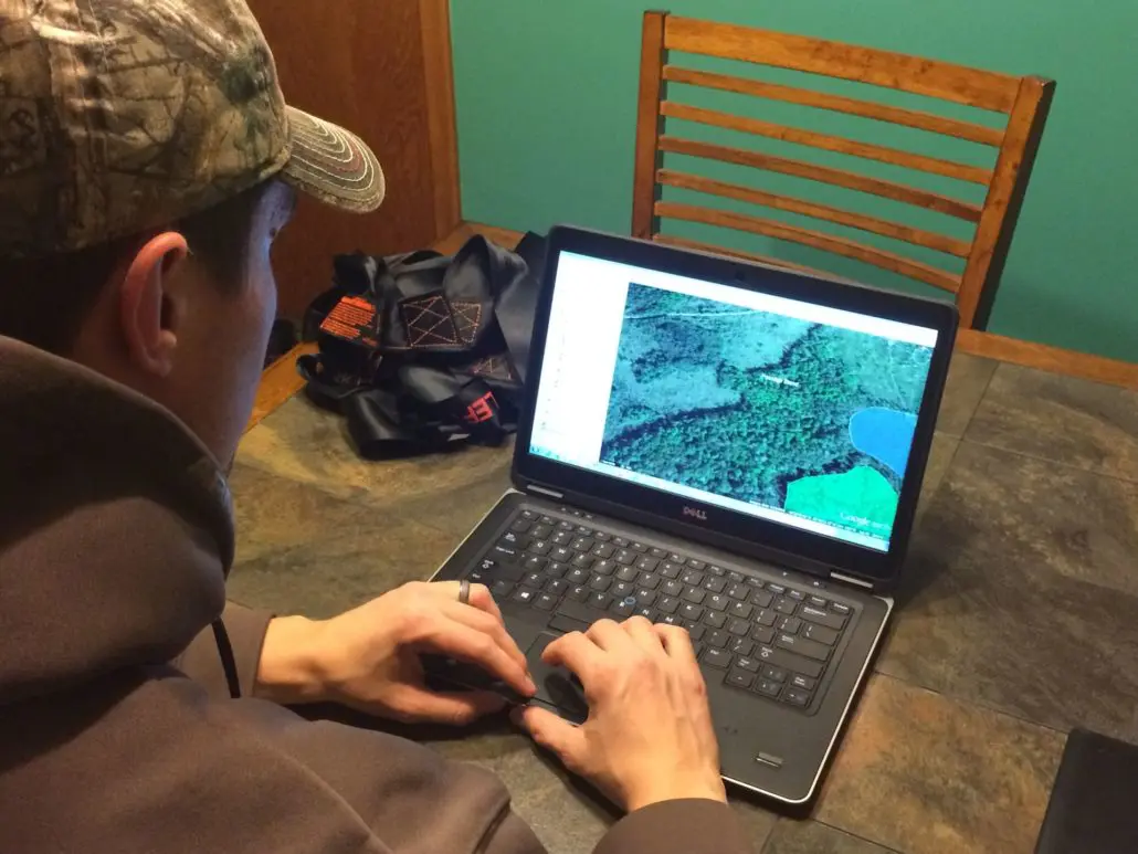
Aerial scouting would be way easier if we could ethically go deer scouting with drones. But even with its slightly less exciting approach, it’s still a very effective method of finding high percentage spots to hunt. Simply open up your favorite online mapping program, and navigate to your hunting land. That’s where the fun begins. We’ll talk about that some more below, but first let’s define what we mean by aerial scouting.
What’s the Difference?
Traditional scouting means boots-on-the-ground walking of public or private land properties. It’s time- and labor-intensive and you may go through all of the effort to find nothing. But you can also learn a lot about a new property using that approach, so don’t completely throw it out the window. Aerial scouting consists of opening up a deer scouting software and doing a lot of that legwork before you even physically set foot there. You can do it from a library, in your home office, or even lounging on the couch. Once you locate some good-looking spots from the map, you can then field verify them using the traditional deer scouting techniques. It allows you to cover way more ground, but you do need to eventually physically investigate a site before you commit to hanging tree stands. Those are the primary benefits and drawbacks of each scouting approach. Now let’s discuss how you can start your aerial assault.
How to Use Aerial Deer Scouting
The best thing about aerial scouting is that it frees up your time by eliminating 90 percent of a property before you even arrive. That’s time not spent wandering through the woods getting poison ivy or battling mosquitoes, which is undeniably great. But since time is our most precious commodity, that time-saving aspect is worth its weight in gold.
Deer Hunting Strategies| Scouting A New Property With Aerials
(Video) – There is a wrong way and a right way to scout. This especially true when we are just months or even weeks out from deer hunting season. The key during this late summer period is minimal disturbance and scouting smart.
As we briefly mentioned, download and install any deer hunting mapping software you want to use. Alternatively, Google Earth is one of the easiest free deer scouting software programs to use and it’s very user-friendly for a wide audience. You can find dozens of different map features (layers) online that can help you for scouting whitetails. For example, many counties offer free layers with property ownership information, which is basically a plat book on steroids. Many governmental agencies provide wetland, topographic, soil, or land cover layers, which you can turn on and off to create your perfect map. To find these layers, simply use a search engine to look for terms like, “topographic map google earth.” After collecting the data sources, it’s time to start deer scouting the smart way.
If you’re simply looking for new spots to hang your tree stands on a property you already have access to hunt, jump ahead at this point. If you’re looking for a new property, turn on the plat map layer to find public lands near you or promising private lands that you could then ask the landowner to hunt. Once you find some spots that look good, you’re ready to continue.
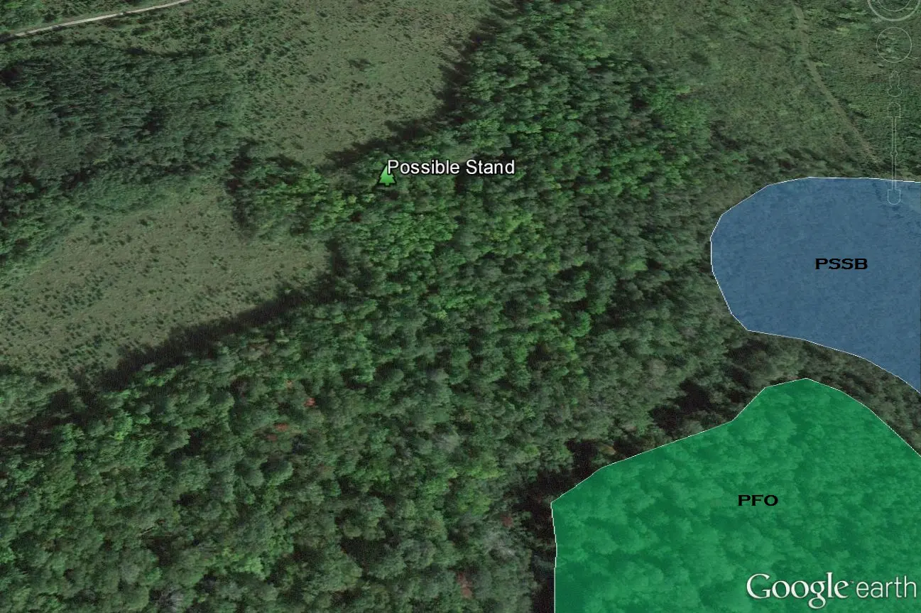
Start by turning on the wetlands layer, and you’ll likely eliminate many spots right off the bat that look like forest on the aerial but are actually intense shrub swamps you wouldn’t want to venture into with a tree stand. Locate any likely feeding areas by looking for open meadows, agricultural fields, pastures, or recent clear cuts. Since whitetails are browsing generalists, you can bet that they feed just about anywhere there is vegetation, but these are the most likely spots to focus on. If you wish, use the mapping tools to draw a green colored polygon (or any other color you prefer) around each one so that they stand out as feeding areas. Once you’ve found those, now try to pick out possible bedding areas. These will be much more challenging since deer can bed anywhere. However, south facing ridge slopes, conifer clusters, upland islands surrounded by wetlands, prairie grass plantings, and regrown clear cuts are some good spots to look for. Now mark these spots with a different colored polygon (brown or your preference).
Now we’re getting somewhere! Many people wonder how to find deer trails. Using only these two types of locations, look for possible travel routes between them, and you’re set. This is where it’s helpful to turn on topographic layers. Deer are fairly lazy creatures, and prefer to travel parallel to contour lines instead of against them, meaning they would rather walk along a ridge than straight up and down it. They’ll obviously make exceptions if the elevation changes aren’t very severe or if they get spooked, but keep this in mind as you’re searching. Also look for areas that are connected by natural or manmade corridors (e.g., logging trail connecting two clear cuts, conifer hedgerow connecting two fields, etc.). In agricultural areas, these travel corridors should be obvious and will likely be shrubby hedgerows and overgrown fence lines. Basically, any kind of structure that crosses relatively open agricultural land or fields will be used. On heavily forested properties, however, these trails may just follow the edge between two different habitats. Deer have plenty of structure in a forest, so you’re just looking for where several habitat types come together.
Using those corridors, try to identify a location along them that really funnels them to a good hunting spot. We call these spots “pinch points” because they squeeze the deer activity into a tightly bound location. Some examples include a six row windbreak narrowing down into two rows, a beaver pond and river coming together to funnel deer movement between them, or the middle of an hourglass-shaped food plot. If you can identify a spot like this that is near some mature trees where you could set your tree stands up, then you can move on to the next step below. If not, keep scanning the aerials to find a decent ambush site.
Field Verification
Now that you’ve theoretically found a handful of good tree stand locations, it’s time to put some miles on the boots and make sure that your hunches are correct. Whether it’s the middle of the summer or you’re doing some post season deer scouting, print out a map with your polygons and stand sites labeled on the aerial and bring it with you to the field. It may also be helpful to download Google Earth or similar mapping software on a smartphone (there are several smartphone hunting apps) so you can see exactly where you’re at and tweak your stand location while you’re in the woods.
Whether you use paper maps or technology, navigate to your pre-selected spots and take a look around. Does it look like you had envisioned when you were sitting at the computer screen? If it’s clearly not where you want to hunt, move on to the next spot. If it has some potential, though, it’s time to investigate a little more thoroughly. Even if it takes some slight re-adjustments of the original location, at least you didn’t spend all day wandering the woods to find it.
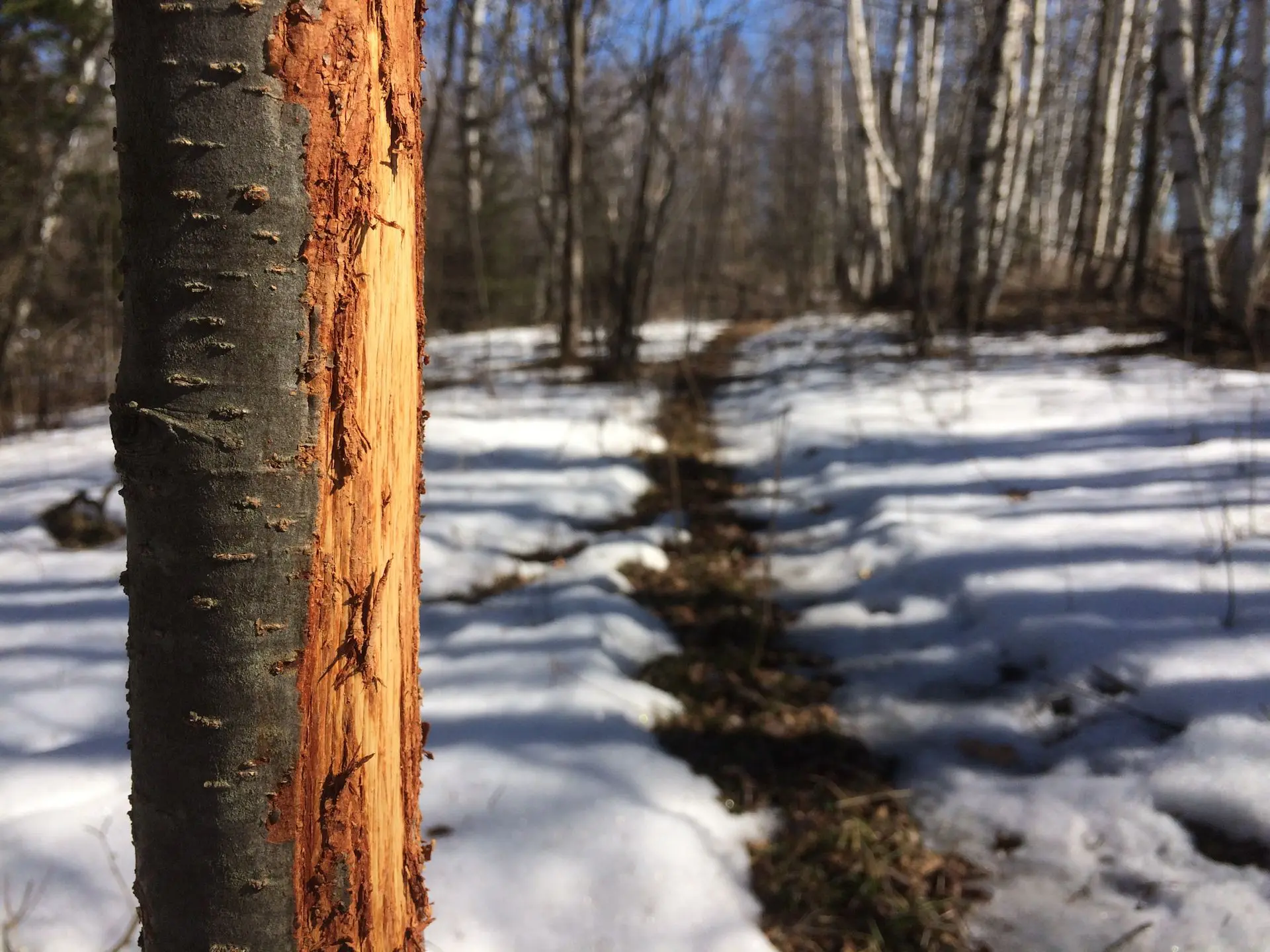
Scan your surroundings for deer sign along the funnel areas. If you chose well, you should be able to find a deer trail, droppings, or rubs without too much effort. Ideally, you’ll find a heavily-worn trail with plenty of scat, and several past rubs lining the way. Now do you see any good-sized trees overlooking this trail that could hide your profile once sitting in the stand? Try to stay away from aspen, ash, or birch trees as they generally don’t have a wide enough profile to hide your silhouette. However, oaks, maples, and conifers usually have enough structure at height to help you disappear.
Stealthy Access and Wind Direction are Critical
Alright, you think you’ve found the perfect spot, but did you miss something important? Most hunters focus too much on the stand location in terms of deer sign, and completely neglect the access side of things. This is one of the most important deer scouting tips. If you can’t sneak in and out of your location without spooking the deer, then the perfect tree you found is actually garbage. By hunting it, you risk disrupting normal deer behavior and travel patterns, making your top-notch pinch point useless. Similarly, if you see a perfect tree on the predominantly upwind side of the trail and still decide to hang a stand there, you could spend more time educating deer to your presence than seeing mature bucks. And that is not the goal.
Take another look at the aerial map and see if there’s a way you could approach and leave the stand location without crossing the deer trail or otherwise leaving any sign you were there. Since you’re perched on a deer trail versus bedding or feeding areas, it should be a little easier to do, but keep this in mind. For example, is there a ditch or creek near the funnel that you could use to navigate there without leaving much sign? Is there a steep ridge that deer are unlikely to use that you could approach from? Even if it means going out of your way a bit, it’s better to err on the side of caution when it comes to entry and exit routes. Yet many people ignore these basic whitetail deer hunting strategies because they get lazy.
Don’t set up tree stands on the upwind side of a trail if you can possibly help it. It’s better to choose a less-concealing tree downwind than perching in a great tree upwind. Why? You can sometimes fool a whitetail’s vision if you dress appropriately and don’t move. But it’s pretty much impossible to convince them you’re a tree after they get a nose full of human scent. For most of the whitetail range, the predominant wind direction is from the northwest, but there will be localized differences depending on the topography. Make an effort to understand that before you commit to a hunting spot.
The Best Tree Stands for Different Situations
Whew! You finally found the perfect hunting spot using your aerial deer scouting techniques and field verifying them. Now you need to decide what type of tree stand is best for the location. If your resources are somewhat limited, you may only have one stand to choose from, which makes this section pretty easy for you. But if you have a couple different types hanging in the garage or shed, this process can make a big difference in the ease of hunting and your ultimate success.
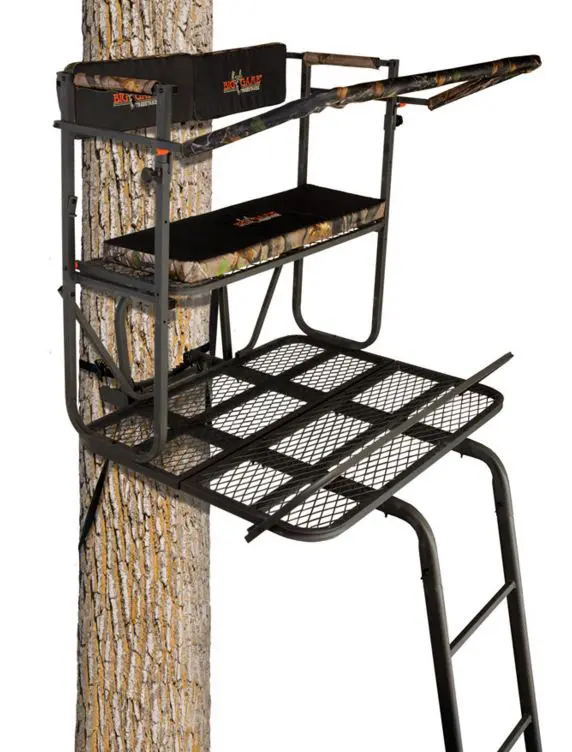
First, consider how difficult it would be to physically get tree stands to your final location. For example, do you really want to weave a ladder stand through a maze of aspen trees or brush, or haul it up a steep ridge by yourself? We’re guessing not. But a fixed position tree stand or climbing stand would be relatively easy to carry into remote sites full of the conditions above. Alternatively, if you’re hunting an open field or food plot with good access, you could easily use a side by side or ATV to haul a double-wide stand in. Along those same lines, will you be the only one hunting from the stand, or do you plan to take your kids with? The Duo is a great option for bringing along a hunting partner, no matter the age. The footrest, seat, and shooting rail all flip back to offer more room on the platform while setting up, but the stand is big enough for two people and is rated to hold 500 pounds of hunter and gear. For these reasons, it’s also one of the best ladder stands for big men, as well.
If you use hunting stands and blinds alike, you’re familiar with the challenges of private versus public land. When you primarily hunt on private land, you can leave your stands up throughout the season without much fear of it being stolen. Since you have that option, you can also choose larger, more permanent stands such as a tripod tree stand or box blind. But if you’ll be hunting public land, you’ll probably want to choose a climbing tree stand or fixed position stand that you can take with you or hope nobody notices it if you do leave it out. Your hunting personality will also play a role in deciding which tree stand to use. If you like to be very comfortable while in the woods and have all the tree stand accessories, including camouflage tree stand blinds, then a more spacious model might work better.
These considerations will all help you narrow down what kind of tree stands you decide to use. Whichever one you choose for your situation, you need to make sure that it’s safe by doing seasonal maintenance. The best option is to take it down at the end of the season and tighten all bolts, grease any moving parts, and renew your cables or straps.
The Final Touches
As you can now hopefully see, aerial deer scouting saves you from walking many, many miles to find new hunting hot spots. By first screening hunting properties and the land cover on them, you can eliminate 90 percent of the area, which saves you time and effort. Then you can focus on really examining the high priority spots in person. So this next season, spend some time deer scouting the smart way, with a refreshing beverage in hand and sitting on the couch.


Leave a Reply
Want to join the discussion?Feel free to contribute!